


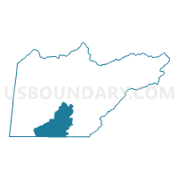
Voting District NOTL, Cherokee County, North Carolina
About
Outline

Summary
| Unique Area Identifier | 639671 |
| Name | Voting District NOTL |
| County | Cherokee County |
| State | North Carolina |
| Area (square miles) | 35.93 |
| Land Area (square miles) | 34.78 |
| Water Area (square miles) | 1.14 |
| % of Land Area | 96.82 |
| % of Water Area | 3.18 |
| Latitude of the Internal Point | 35.03408080 |
| Longtitude of the Internal Point | -84.13338990 |
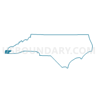
Maps

Graphs
Select a template below for downloading or customizing gragh for Voting District NOTL, Cherokee County, North Carolina


Neighbors
Neighoring Voting District (by Name) Neighboring Voting District on the Map
- 111FAIR - FAIRPLAY Voting District, Fannin County, GA
- 2917 - DOOLEY Voting District, Union County, GA
- Voting District BEAV, Cherokee County, NC
- Voting District BELL, Cherokee County, NC
- Voting District HIWA, Cherokee County, NC
- Voting District HOTH, Cherokee County, NC
- Voting District MURN, Cherokee County, NC
- Voting District MURS, Cherokee County, NC
Top 10 Neighboring County Subdivision (by Population) Neighboring County Subdivision on the Map
- Murphy township, Cherokee County, NC (10,921)
- Ivylog CCD, Union County, GA (7,781)
- Notla township, Cherokee County, NC (4,570)
- Mineral Bluff CCD, Fannin County, GA (3,525)
- Shoal Creek township, Cherokee County, NC (2,290)
- Hothouse township, Cherokee County, NC (1,591)
Top 10 Neighboring Unified School District (by Population) Neighboring Unified School District on the Map
- Cherokee County Schools, NC (27,444)
- Fannin County School District, GA (23,682)
- Union County School District, GA (21,356)
Top 10 Neighboring State Legislative District Lower Chamber (by Population) Neighboring State Legislative District Lower Chamber on the Map
- State House District 120, NC (72,565)
- State House District 7, GA (55,327)
- State House District 8, GA (53,313)
Top 10 Neighboring State Legislative District Upper Chamber (by Population) Neighboring State Legislative District Upper Chamber on the Map
Top 10 Neighboring 111th Congressional District (by Population) Neighboring 111th Congressional District on the Map
Top 10 Neighboring Census Tract (by Population) Neighboring Census Tract on the Map
- Census Tract 1.02, Union County, GA (5,088)
- Census Tract 9305, Cherokee County, NC (4,693)
- Census Tract 9306.02, Cherokee County, NC (3,931)
- Census Tract 501, Fannin County, GA (3,525)
- Census Tract 9306.01, Cherokee County, NC (3,280)
- Census Tract 1.01, Union County, GA (2,693)
- Census Tract 9303, Cherokee County, NC (2,439)